Geology & History
The landscape of the area is dominated by the Kouga- and Baviaanskloof Mountains, which run parallel to each other in an east west orientation. These are part of the Cape Folded Mountains The Kouga range is the larger of the two. Many high peaks occur in the western and central parts of this range while the eastern end is less rugged with plateau's and hills generally less than 900m in altitude. Smutsberg is the highest peak at 1757m above sea level. The Baviaanskloof Mountains form a long narrow range with Scholtzberg at 1625m being the highest peak. In the east the Baviaanskloof Mountains join the Groot Winterhoek range with Cockscomb being the highest peak, and at I 768m above sea level, the highest peak in the wilderness area.
Two main rivers drain the area, namely the Baviaanskloof- and Kouga River. They converge at Smitskraal from where they flow in an easterly direction to the Kouga dam. The Grootrivier drain the Karoo and flows through the reserve near Komdomo. The Witrivier which has its origins within the reserve joins this.
Although the "modern" Baviaanskloof is about 20 million years old, its precursor dates back 140 million years ago to the break-up of the continents when a major tensional fault formed along what later became known as the Baviaanskloof. Erosion, together with repeated subsidence and upliftment events have over the course of millions of years created the landscape one views today. Contrasting with the steep rugged gorges and mountain slopes are some remarkably flat plateau's at an altitude of 650-900m. These are part of what is known as the African Land Surface, an old "mature" land surface which can be found over large parts of sub-Saharan Africa. The Table Mountain formations upon which this surface lies are hard and resistant to erosion with the result that the African Land Surface is well preserved within the BWA.
Quartzitic sandstones of the Table Mountain Group dominate the landscape as a whole. All formations belonging to this group can be found in the area, and of these, the Peninsula Sandstone Goudini Sandstones and Cedarberg shales are predominant.
Formations:
Peninsula Sandstone - the oldest formation which usually dominates at higher altitudes and the peaks.
Cedarberg Shale - it separates the Peninsula from the Goudini formation with a 10-40m wide bar and is usually associated with lower lying necks and saddles.
Goudini Sandstone - is generally brown in colour and can often be recognised by the numerous shallow caves in the cliffs.
Skurweberg Sandstone - is associated with the Cockscomb and most of the higher peaks of the Baviaanskloof range.
Sardinia Bay - is mixed with phyllitic shales and small-pebble conglomerate. It can be seen at low altitudes at the eastern end of the Baviaanskloof range.
Baviaanskloof - is dark in colour and, along with the Sardinia Bay formation, is relatively uncommon.
A number of other formations are present but are insubordinate in the landscape. Noteworthy one~ include the Grahamstown Formation which can be found on the flat plateau surfaces and has been termed the African Land surface, and the Enon Conglomerate Formation, a red formation which erodes into dramatic shapes. The only exposed granite formation in the Eastern Cape (as depicted on geological survey maps) occurs within the BWA.
HISTORY
The Baviaanskloof (Valley of Baboons) was once home to San hunter-gatherers and early 18th century settlers, who progressed from hunter to nomadic pasturalist, to a more permanent lifestyle based on agriculture.
The area was once important for the cultivation of pure vegetable seed (onion, carrot, beet root and pumpkin), the mountainous isolation preventing contamination of seed stock. Goats were farmed for the angora goat industry and together with seed production, represented a viable industry.
From the 1920's it has been managed by The Department of Nature Conservation. Large parts have always been State or "Crown" lands. The construction of the Kouga Dam (or Paul Sauer Dam as it was then known) in the 1960's and early 1970's led to much land being bought out and transferred to the Department of Forestry. in 1987 the management of the area was transferred to Cape Nature Conservation and more land was bought out with private funds for the consolidation of the area. Since 1994 it has been managed by Eastern Cape Nature Conservation.
 Gamtoos Geology
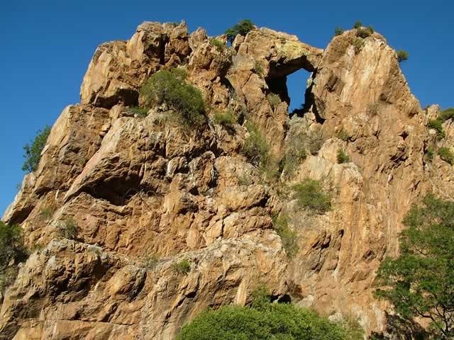 Gamtoos Geology Rock Formations
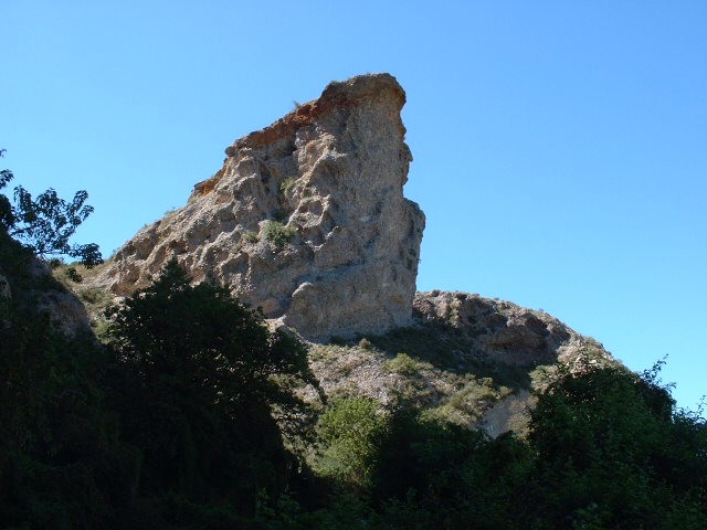 Gamtoos Geology Enon Conglomerate